Yukon Metals Identifies High-Priority Drill Targets at Birch
VANCOUVER, British Columbia, Jan. 08, 2025 (GLOBE NEWSWIRE) — Yukon Metals Corp. (CSE: YMC, FSE: E770, OTCQB: YMMCF) (“Yukon Metals” or the “Company”) is pleased to provide results of an Electrical Resistivity Tomography (ERT) and Induced Polarization (IP) geophysical survey program over its 7,000-hectare Birch Property (“Birch”), located 65 km northeast of Burwash Landing, Yukon. Birch is one of Yukon Metals’ seventeen high-quality properties across 42,500 hectares in the Yukon.
Highlights:
- Yukon Metals geologists completed eight ERT and IP geophysical surveys over the eastern portion of the 2024 soil sampled copper and gold anomaly at Birch. The survey identified several high-priority drill targets.
- Structural geological features can be inferred from the geo-electric signatures of the rock, guiding drill placement.
- The new geophysical data aligns with previously identified soil anomalies of up to 0.24% Cu in soils and up to 0.99 g/t Au spanning 1400 meters, and rock chip sampling with values up to 2.42% Cu and 14.1 g/t Au, further emphasizing the project’s potential for significant mineralization.
- All sections intersecting the soil anomaly zone showed geophysical anomalies below surface that are interpreted to correspond to changes in rock type and sulphide mineralization in skarn horizons over several hundred meters.
Rory Quinn, President & CEO stated, “With this geological survey program, which includes induced polarization, surface mapping, and soil and rock sampling programs, Yukon Metals is closer to uncovering the mineral potential of the highly prospective Birch Property. The next step will be to commence drilling at Birch, targeting mineralized skarn horizons.”
The survey identified several high-priority geophysical anomalies supporting the next phase of exploration. These results mark an important step forward in advancing Birch as a highly prospective property for precious and base metal mineralization. The geophysical data is being integrated with surface geochemical results, geological mapping, and previously collected airborne magnetic survey data, to define both high-priority drill targets, and areas for future exploration.
The ERT and IP surveys were conducted to study the electrical properties of the area’s dominant rock formations, including limestone, marble, schist, and granite. Structural geological features and contacts can be inferred from the geo-electric signatures of the rock, guiding drill placement.
These techniques involve sending electrical currents into the ground and measuring how different materials respond, creating detailed subsurface maps that highlight geological layers and structures. Induced polarization measures how certain materials, like metallic minerals, temporarily store and release electrical charge, often indicating the presence of sulfides. Conductivity indicates rock containing electrically conductive minerals such as sulphides and metallic elements. Resistivity is used to guide identification of rock type, delineate rock types, depth of overburden and identify anomalous zones.
Advanced software processed the data to produce high-resolution images, helping identify key geological features such as bedrock layers, mineralized zones, and areas of uncertainty.
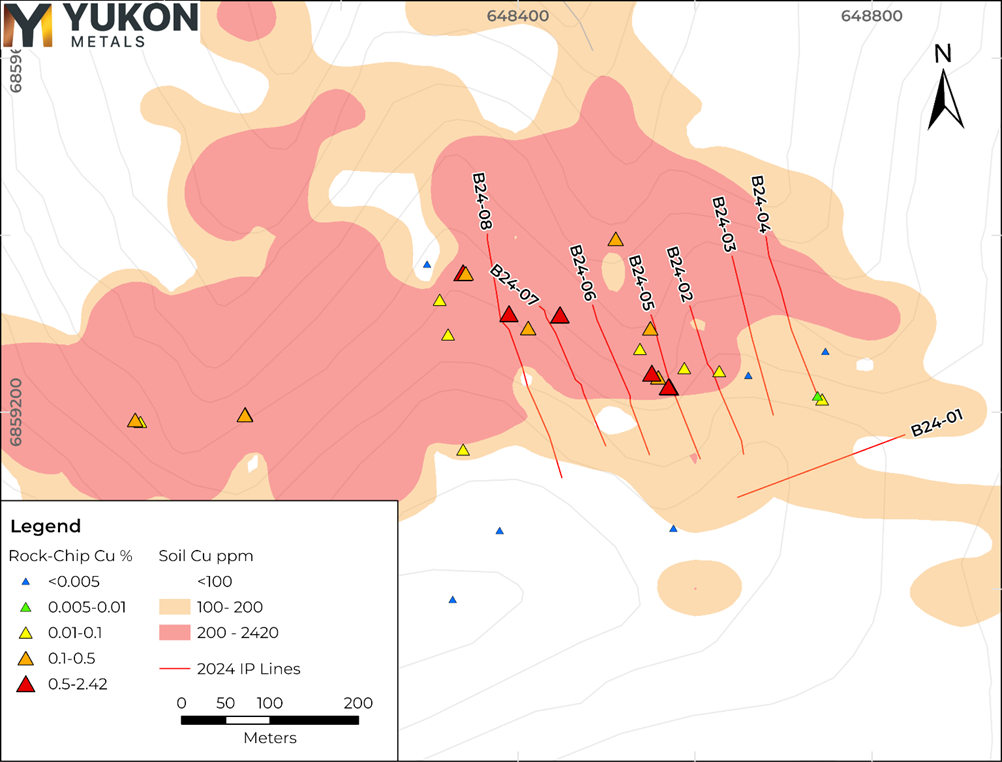
Figure 1- 2024 Geophysics Lines with anomalous Copper in Soil and Rock Samples.
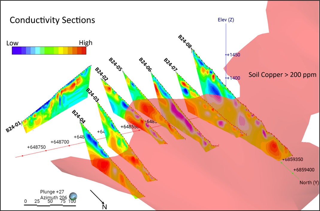
Figure 2- Conductivity sections with overlain 2024 copper-in-soil greater than 200 ppm. High conductivity zones (red) show a strong, continuous anomaly across six of the parallel surveys, potentially indicative of mineralized zones
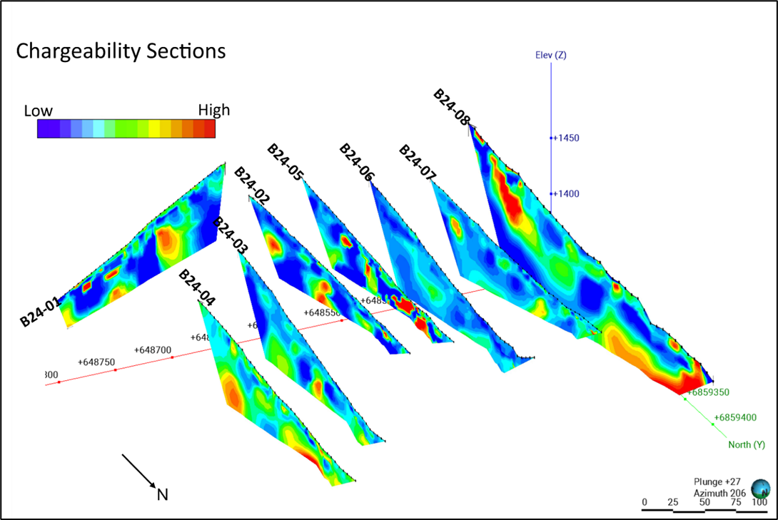
Figure 3- 3d views of Induced Polarization chargeability sections. High chargeability zones (red) potentially indicative of sulphide mineralization and consistent with skarn geophysical signatures are visible in most of the surveys.
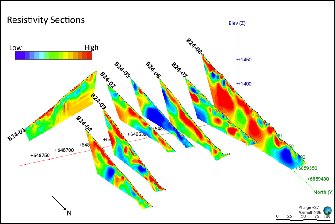
Figure 4- 3d views of Resistivity sections. Deep, high resistivity zones (red) are likely schist. Low resistivity zones (blue) are likely marble, intrusive granodiorite or mineralized skarns. The prospective low resistivity zones align with IP chargeability and conductivity highs. Near-surface high resistivity (red) may be permafrost surficial colluvium.
About the Birch Project
Yukon Metals owns 100% of the helicopter-accessed Birch project located 65km northeast of the community of Burwash Landing. The Birch project area is dominated by frost-heaved boulders in unglaciated terrain, with outcrop present on steeper ridges. The project lies predominantly within the Finlayson assemblage of the Yukon-Tanana Terrane, consisting of variably carbonaceous schist and quartzite, marble, garnet amphibolite and rare metaplutonic rocks.
The Yukon-Tanana Terrane structurally overlies the Ruby Range Batholith which is regionally mapped in the northeastern portion of the property occurring as Ruby Range quartz-feldspar porphyry and Rhyolite Creek porphyry and intermediate and felsic volcanic rock (Israel et. Al., 2011). Project-level mapping indicates the geology of the area is comprised of schists and marble units, moderately to strongly oxidised felsic intrusive, and patchy oxidised porphyritic rhyolite dykes.
Copper, zinc and molybdenum mineralization was first identified in the area in the early 1970s as part of a small exploration campaign which uncovered several skarn horizons in the northern project area, as well as molybdenite in quartz veins and stringers in granodiorite float on the southeastern side of the property (MINFILE 115G 077). Gold was not assayed for until interest renewed in the early 2010s with soil and mapping exploration work over the area uncovering several high soil anomalies ranging from 0.02-15g/t Au.
The Birch claims were staked over skarn copper and soil gold anomalies in 2022 by Lapie Mining Inc., and subsequently acquired by Yukon Metals in 2024 as part of the Berdahl land package. Highlights from the 2024 prospecting and geochemical program include soil samples across the northern and central sections of the claim block revealing significant gold, copper, and molybdenum mineralization. A particularly strong copper and gold anomaly has been identified in the northern portion of the block, extending roughly east-west over 1,400 meters, signaling an exciting target for further exploration. Additionally, rock-chip float samples from the eastern segment of this anomaly have shown impressive values.
Methodology
Geophysical Survey
A Lippmann 4-point Resistivity System was used. A 200-300 m cable configuration was selected for high near-surface detail and 50-100 m of depth penetration. Data was collected and inverted using Advance Geophysics Inc. Earth Imager 2D software. Noisy data points and electrodes with poor contact resistance were removed and data was filtered for spikes or depressions in resistivity. The software produced two-dimensional tomograms using a smoothed, least squares damped and robust inversion parameters. Preliminary interpretations were conducted.
The chargeability, conductivity, and resistivity scales shown on the individual survey sections are not standardized across all sections and may vary to effectively highlight local geological features. Variations in scale are used to optimize the visualization of anomalies and do not imply absolute differences in geophysical values between sections. Conductivity ranges from 0.01 to 3.9 ms/M, chargeability from -3 to 45 ms, and resistivities from 200-50,000 Ohm-m.
Rock and Soil Sampling
Rock and soil samples were sent to ALS Minerals for analysis with sample preparation in Whitehorse, Yukon and analysis in North Vancouver, British Columbia.
Rock samples were prepared by crush to 70 % passing 2mm, 250g split pulverised better than 85% passing 75 microns (Prep-31A). Pulp samples were analysed for 34 elements by four acid digestion and ICP-AES (ME-ICP61). All samples were analyzed for gold by fire assay and AAS with a 50g nominal sample weight (Au-AA24). Samples over 10g/t Au were assayed by 50g sample fire assay with gravimetric finish (Au-GRA22).
Soil samples were collected with a battery-powered permafrost soil drill recovering high-quality samples below boulders and frozen ground to depths of 1m. This technique was designed specifically for Yukon geochemical exploration to better delineate mineralization along steep, rocky and permanently frozen north-facing slopes unsuitable for traditional soil sampling techniques. Samples were dried and sieved to 180 um (Prep-41A) and analysed for 51 elements by aqua regia digestion and ICP-MS and ICP-AES (AuME-TL44).
Rock samples taken while prospecting referenced in this release are selective in nature and collected to determine the presence or absence of mineralization and may not be representative of the mineralization hosted on the project.
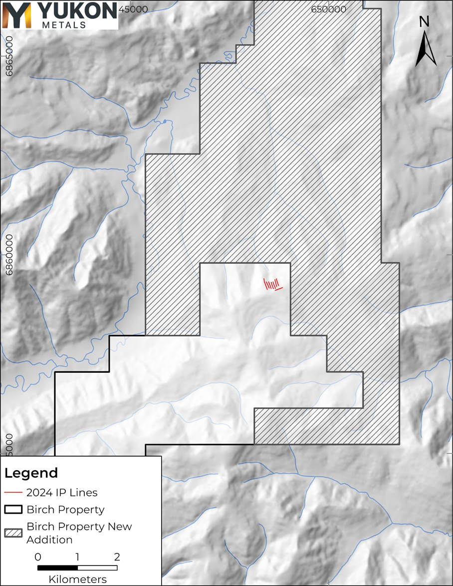
Figure 5- IP and Resistivity line locations on the Birch Property
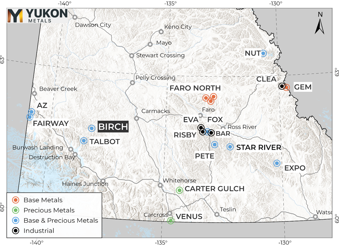
Figure 6- Birch project location map with relation to other YMC properties
Qualified Person
The technical content of this news release has been reviewed and approved by Helena Kuikka, P.Geo., VP Exploration for Yukon Metals and a Qualified Person (as defined by National Instrument 43-101).
About Yukon Metals Corp.
Yukon Metals is well financed and represents a property portfolio built on over 30 years of prospecting by the Berdahl family, the prospecting team behind Snowline Gold’s portfolio of primary gold assets. The Yukon Metals portfolio consists primarily of copper-gold and silver-lead-zinc assets, with a substantial gold and silver component. The Company is led by an experienced Board of Directors and Management Team across technical and finance disciplines.
Yukon Metals is focused on fostering sustainable growth and prosperity within Yukon’s local communities, while simultaneously enhancing stakeholder value. Our strategy centers around inclusivity and shared prosperity, offering both community members and investors the chance to contribute to, and benefit from, our ventures.
The Yukon
The Yukon ranks 10th most prospective for mineral potential across global jurisdictions according to the Fraser Institute’s 2023 Survey of Mining Companies and is host to a highly experienced and conscientious local workforce, fostered by a long culture of exploration coupled with deep respect for the land. Recent major discoveries with local roots such as Snowline Gold’s Rogue Project – Valley Discovery, demonstrate the Yukon’s potential to generate fresh district-scale mining opportunities.
ON BEHALF OF THE BOARD OF YUKON METALS CORP.
(signed) “Rory Quinn”
For more information, please contact:
Rory Quinn, President & CEO
Email: [email protected]
CAUTIONARY NOTE REGARDING FORWARD-LOOKING INFORMATION
This news release contains certain forward-looking information, including information about the metal association and geology of the prospect area at Birch pointing to the prospectivity for a gold-rich copper porphyry system, significant scale having been demonstrated by a soil anomaly over 1,400 meters long, the potential for economic grades of copper and gold based on grades taken from surface rock chips, the Yukon’s potential to generate fresh district-scale mining opportunities, and the Company’s future plans and intentions. Wherever possible, words such as “may”, “will”, “should”, “could”, “expect”, “plan”, “intend”, “anticipate”, “believe”, “estimate”, “predict” or “potential” or the negative or other variations of these words, or similar words or phrases, have been used to identify the forward-looking information. These statements reflect management’s current beliefs and are based on information currently available to management as at the date hereof.
Forward-looking information involves significant risks, uncertainties and assumptions. Many factors could cause actual results, performance or achievements to differ materially from those discussed or implied in the forward-looking information. Such factors include, among other things: risks and uncertainties relating to Birch not being a prospective gold-rich copper porphyry system, not having significant scale and a lack of economic grade minerals; the Yukon not having the potential to generate fresh district-scale mining opportunities; and other risks and uncertainties. See the section entitled “Risk Factors” in the Company’s listing statement dated May 30, 2024, available under the Company’s profile on SEDAR+ at www.sedarplus.ca for additional risk factors. These factors should be considered carefully, and readers should not place undue reliance on the forward-looking information. Although the forward-looking information contained in this news release is based upon what management believes to be reasonable assumptions, the Company cannot assure readers that actual results will be consistent with the forward-looking information. The forward-looking information is made as of the date of this news release, and the Company assumes no obligation to update or revise the information to reflect new events or circumstances, except as required by law
References
Israel, S., Murphy, D., Bennett, V., Mortensen, J. and Crowley, J., 2011. New insights into the geology and mineral potential of the Coast Belt in southwestern Yukon. In: Yukon Exploration and Geology 2010, K.E. MacFarlane, L.H. Weston and C. Relf (eds.), Yukon Geological Survey, p. 101-123.
Photos accompanying this announcement are available at:
https://www.globenewswire.com/NewsRoom/AttachmentNg/64fc59db-8264-4522-a842-e8de3ff0f658
https://www.globenewswire.com/NewsRoom/AttachmentNg/ccc87d28-6430-4adf-ba74-2c5281b3ec88
https://www.globenewswire.com/NewsRoom/AttachmentNg/e421b09b-19e3-40cb-b270-83d992c6f139
https://www.globenewswire.com/NewsRoom/AttachmentNg/965bfe55-1817-458a-9d77-ebf83bc8042e
https://www.globenewswire.com/NewsRoom/AttachmentNg/11a088d5-e2ea-454f-afc5-cbc7adddb346
https://www.globenewswire.com/NewsRoom/AttachmentNg/4b4071d9-e0f7-4b9b-937e-10c517bf3e55


