VR Resources Outlines Targets for Upcoming Drilling at Silverback Copper-Gold Project in Ontario
VANCOUVER, British Columbia, Jan. 07, 2025 (GLOBE NEWSWIRE) — VR Resources Ltd. (TSX.V: VRR, FSE: 5VR; OTCBB: VRRCF), the “Company“, or “VR”, is pleased to provide further details on the upcoming drill program planned for later this month at its Silverback copper-gold project in Northwestern Ontario.
- The drill program is targeting three high-priority areas identified through the recently completed 3D array DCIP chargeability survey completed in late November 2024, as illustrated in Figure 1.
From VR’s CEO Justin Daley: “Our exploration at Silverback has steadily progressed from broad regional surveys and local prospecting to targeted drilling, all guided by modern mineral deposit modelling. Despite widespread thin glacial cover and few outcrops, we are happy to see important geological and structural features consistently characterized across our independent geophysical datasets. We plan to drill test these target areas for mineralization with a series of scout holes designed for optimal logistics and cost-effectiveness. To that end we are clearing access roads of snow and cutting drill trails and building pads in the high-priority areas for drilling later this month.
The remainder of this news release provides an illustration of the targets themselves. We want to highlight the broad array of data involved, and emphasize the shear scale of the mineral system across 2.5km. The integration of modern 3D DCIP technology with both historic and recent airborne EM and magnetic data, together with recent prospecting and drilling on the ground gives us a clear picture of where mineralization is concentrated. With the newly defined targets—centered on well-defined shear zone structures and supported by early drilling results—we are giving ourselves the best chance at identifying areas of remobilized copper and gold mineralization above and within an intrusion-related source.”
The 2024 DCIP Survey
The survey delineated three near-surface IP anomalies that correlate with conductivity zones in a previous, and independent airborne frequency-domain EM and magnetic survey. Each target area shown in Figure 1 is focused on north-south trending shear zones, and more specifically, where these structures intersect the edges of nickel-chrome bearing mafic-ultramafic bodies and dykes. These mafic intrusions and their contacts are outlined by high magnetic response, are confirmed by prior drilling, and appear to predate the gold-mineralized porphyry intrusion and subsequent shearing. As such, they can provide crucial crustal pathways for hydrothermal fluids and act as chemical traps, making them ideal environments for hydrothermal copper-gold deposition.
Target Area 1 – Central Zone (CZ)
- The largest high-amplitude IP anomaly 1.2 km long is in the center of the project area and follows the north-south trending structural break. This structure is also associated with outcrops of sheared gabbro with high grade copper-gold mineralization (Photo 1A), and with the occurrence of molybdenite on fractures (Photo 2).
- The IP anomaly comes to surface along a parallel trend of shearing, approximately 300 meters east of the main showing in an area of glacial cover, as illustrated in Figure 1, Section A.
- The magnetic response of the east-west trending mafic body forms a trough across the IP anomaly, possibly due to demagnetization from hydrothermal alteration along the Central Zone structure (Figure 2).
- To the north, beyond the 1,200-meter-long IP anomaly, the Central Zone structure continues as near-surface DIGEM conductivity anomalies, potentially caused by clay alteration, as observed in Hole 2 from previous drilling.
Target Area 2 – North Arm (NA)
- Located northeast of the Central Zone, the North Arm target area consists of a 400 by 800-meter low-amplitude chargeability anomaly, along the western edge of a magnetic high, where the east-west trending mafic intrusion is offset more than 1 km by the North Arm shear zone.
- Intrusion-related quartz-carbonate veining with sulfide within the mafic intrusion (Photo 1C) that was discovered during the IP survey occurs where the IP anomaly comes to surface on Figure 1, Section B.
- The structure coincides with a 6-channel EM anomaly in an historic Ontario Geological Survey publication (OGS map M80524), and also with a shallow DIGEM conductor anomaly from the 2023 survey. The 6-channel EM anomaly reflects a subsurface conductive body with strong signals spanning from shallow, fast-decaying responses to deep, slower-decaying responses, indicating potential for a plunging, continuous conductor at the mafic intrusion contact.
- A parallel DIGEM conductor trend, located 200 meters west, may represent a secondary splay of the main structure, bounding the western margin of the “Y” shaped IP anomaly here.
Target Area 3 – West Dyke (WD)
- The West Dyke target is centred on the intersection of another north trending shear structure, which dislocates the subparallel West Dyke near Hole 2, and a west-northwest crustal structure and trend of IP anomalies (see Figure 1).
- The porphyry intrusion in Hole 2, roughly 450 metres south of the West Dyke IP anomaly, appears to have intruded along the eastern flank of the West Dyke, and is associated with a DIGEM conductor anomaly. That conductivity is coincident with and likely caused by the clay and sericite alteration observed alongside the disseminated sulfides and quartz-carbonate veining (Photo 1B) that coincides with a nearby small IP anomaly.
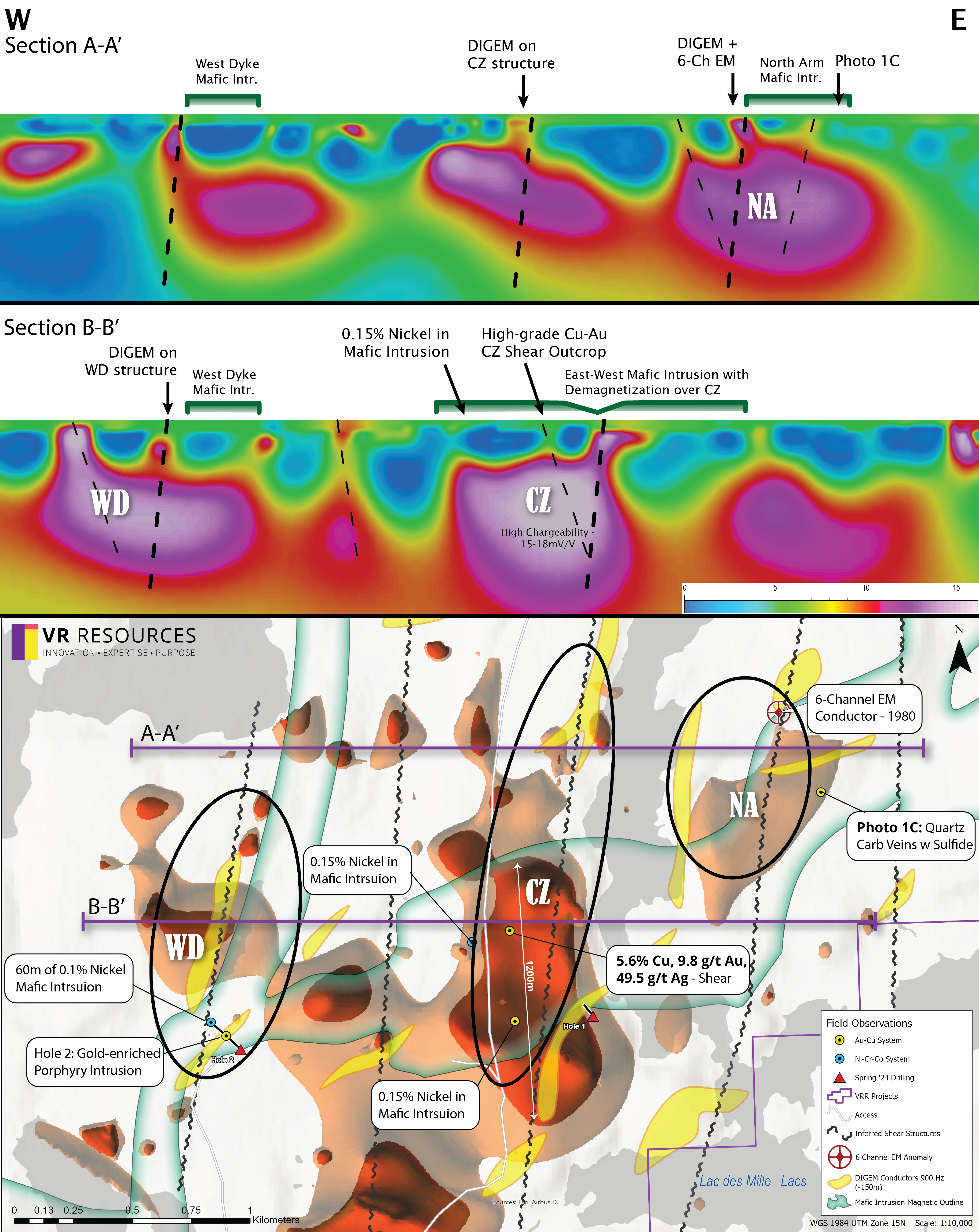
Figure 1. Plan map (lower) and sections (upper) of the recent 3D array DCIP survey at Silverback. The plan map shows IP isoshells at 12.5 mV/V (orange) and 15 mV/V (red) on a basemap with inferred shear-zones and margins of the nickel-mineralized mafic dykes and intrusions which span the entire property. The central and largest IP anomaly (CZ) correlates with the largest blowout of the mineralized mafic dyke, and the strongest shear-fabrics observed in outcrop; the integrated CZ target exceeds 1 km in strike length.
Rock Photos of Mineralization
Upcoming drilling at Silverback will target the potential for high-grade remobilized shear zone mineralization within a deposit model for intrusion-related copper, gold and silver mineralization associated with widespread disseminated sulfides, quartz-carbonate veining (Photo 1) and sericite-chlorite alteration in an Archean porphyry intrusion, first seen in Hole 2 from spring 2024 reconnaissance drilling. The presence of molybdenite on fractures (Photo 2) reinforces an intrusive source for copper and gold mineralization at Silverback, yet also speaks to the temperature and intensity of fluid flow carrying these metals into shear-zone structures. Molybdenum, a critical pathfinder in the Hemlo gold camp, is typically found near the strongest gold mineralization, especially where overprinted by later sericite alteration and quartz-carbonate veining.
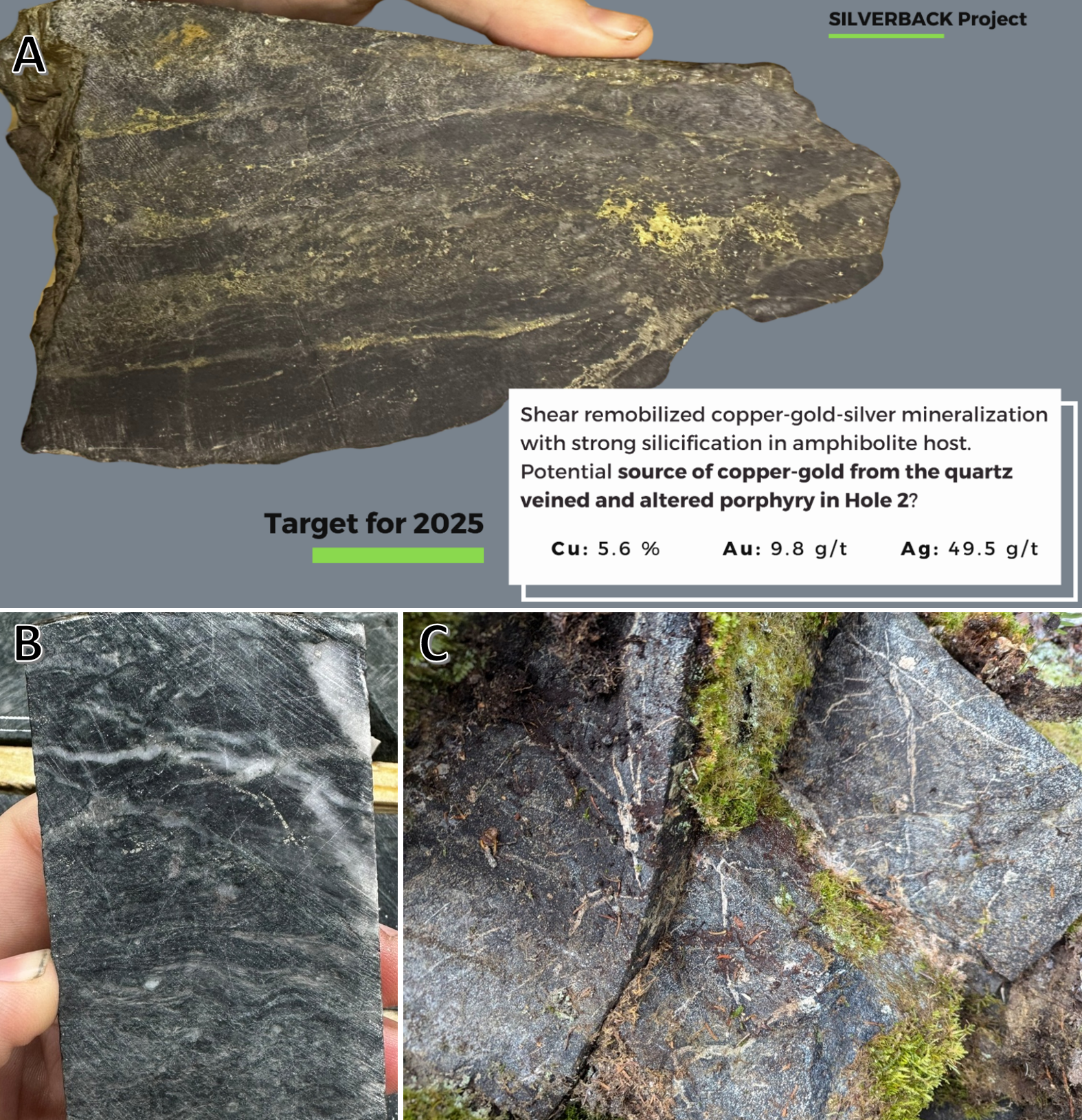
Photo 1. Examples of copper/gold mineralization found across the Silverback project related to an inferred intrusion-related source (refer to map in Figure 1 for location of zones). A: Remobilized copper, gold and silver mineralization in shear zone outcrop with strong silicification at Central Zone. B: Gold mineralized interval of weakly sheared porphyry intrusion at 95m depth in Hole 2 in the West Dyke zone, with quartz-carbonate veining and clay-sericite alteration. C: Quartz-carbonate veining with sulfides recently discovered in the North Arm zone within a dislocated extension of the east-trending mafic intrusion, and with the exact same habit and texture as those in Hole 2 located more than 2,500m to the west.
About the Silverback Project
The project now consists of 71 mineral claims in 1 contiguous block covering 4,442 hectares. The project is located on Federal crown land, with mineral rights administered by the Ontario Ministry of Mines. There is a 2% net smelter royalty on the claims. There are no annual payments, but the Ministry requires certain annual exploration expenditures and reporting (ie. mineral assessment reports) in order to maintain a mineral claim in good standing. The Properties falls within the Lac de Mille Lac First Nation traditional territories.
Technical Information
Surface grab samples and drill core samples were submitted for geochemical analysis to the AGAT laboratory in Thunder Bay, Ontario. Drill core was logged, cut and sampled at the Holbik Exploration warehouse in Upsala, Ontario, with sample preparation completed by AGAT in Thunder Bay alongside gold and PGE determination by atomic absorption assay. ICP-MS analyses for base metals, whole rock, and trace elements is performed at AGAT’s laboratory in Calgary, AB. Analytical results are subject to industry-standard and NI 43-101 compliant QAQC sample procedures, including the systematic insertion of sample duplicates, blanks and certified reference material (CRM) done both externally and internally at the laboratory by AGAT, as described by AGAT.
Technical information for this news release has been prepared in accordance with the Canadian regulatory requirements set out in National Instrument 43-101. The content of this news release has been reviewed on behalf of the Company by Justin Daley, MSc, PGeo, President & CEO at VR, and a non-independent Qualified Person, oversees and/or participates in all aspects of the Company’s mineral exploration projects.
About VR Resources Ltd.
VR is an established junior exploration company based in Vancouver (TSX.V: VRR; Frankfurt: 5VR; OTCQB: VRRCF). VR evaluates, explores and advances opportunities in copper, gold and critical metals in Nevada, USA, and Ontario, Canada. VR applies modern exploration technologies, in-house experience, and expertise in greenfields exploration to large-footprint systems in underexplored areas/districts. The foundation of VR is the proven track record of its Board in early-stage exploration, discovery and M&A. The Company is financed for its mineral exploration and corporate obligations. VR owns its projects outright and evaluates new opportunities on an ongoing basis, whether by staking or acquisition.
ON BEHALF OF THE BOARD OF DIRECTORS:
“Justin Daley”
Justin Daley, MSc, P.Geo
President & CEO
For general information please use the following:
Website: www.vrr.ca
Email: [email protected]
Phone: 778-731-9292

Figure 2. Zoomed-in view of the Central Zone IP chargeability anomaly shown in Figure 1, with a 15.5 mV/V response extending for over 1,200 meters north to south. The mafic intrusion is characterized by a high magnetic response (indicated by closely spaced 20 nT contours), which is strongest on either side of the Central Zone structure. The localized magnetic low within the anomaly may result from demagnetization caused by hydrothermal alteration along the structure
Forward Looking Statements
This news release contains statements that constitute “forward-looking statements”. Such forward looking statements involve known and unknown risks, uncertainties and other factors that may cause the Company’s actual results, performance or achievements, or developments in the industry to differ materially from the anticipated results, performance or achievements expressed or implied by such forward-looking statements. Forward-looking statements are statements that are not historical facts and are generally, but not always, identified by the words “expects,” “plans,” “anticipates,” “believes,” “intends,” “estimates,” “projects,” “potential” and similar expressions, or that events or conditions “will,” “would,” “may,” “could” or “should” occur. Forward-looking statements in this document include statements concerning VR’s expectations that it will share detailed exploration plans and plans for drilling in 2025, and all other statements that are not statements of historical fact.
Although the Company believes the forward-looking information contained in this news release is reasonable based on information available on the date hereof, by their nature forward-looking statements involve assumptions, known and unknown risks, uncertainties and other factors which may cause our actual results, performance or achievements, or other future events, to be materially different from any future results, performance or achievements expressed or implied by such forward-looking statements.
Examples of such assumptions, risks and uncertainties include, without limitation, assumptions, risks and uncertainties associated with general economic conditions; adverse industry events; future legislative and regulatory developments in the mining sector; the Company’s ability to access sufficient capital from internal and external sources, and/or inability to access sufficient capital on favorable terms; mining industry and markets in Canada and generally; the ability of the Company to implement its business strategies; competition; and other assumptions, risks and uncertainties.
The forward-looking information contained in this news release represents the expectations of the Company as of the date of this news release and, accordingly, is subject to change after such date. Readers should not place undue importance on forward-looking information and should not rely upon this information as of any other date. While the company may elect to, it does not undertake to update this information at any particular time except as required in accordance with applicable laws.
This news release may also contain statements and/or information with respect to mineral properties and/or deposits which are adjacent to and/or potentially similar to the Company’s mineral properties, but which the Company has no interest in nor rights to explore. Readers are cautioned that mineral deposits on similar properties are not necessarily indicative of mineral deposits on the Company’s properties.
Trading in the securities of the Company should be considered highly speculative. All of the Company’s public disclosure filings may be accessed via www.sedarplus.ca and readers are urged to review them.
Neither the TSX Venture Exchange nor its Regulation Services Provider (as that term is defined in Policies of the TSX Venture Exchange) accepts responsibility for the adequacy or accuracy of this release
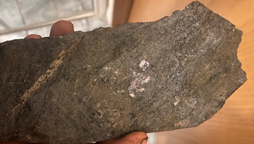
Photo 2. Sample of chlorite-altered mafic intrusion at south end of Central Zone with crystalline molybdenite remobilized onto fracture planes; up to 350 ppm molybdenum in grab sample. This presence of molybdenite is rare in a mafic intrusion setting and was one of the first clues towards an intrusion-related copper-gold deposit model as source for high-grade mineralization further north along the CZ structure.
Photos accompanying this announcement are available at
https://www.globenewswire.com/NewsRoom/AttachmentNg/cb58905b-f720-4baa-b73a-fc87eb6e1ae9
https://www.globenewswire.com/NewsRoom/AttachmentNg/896281c7-17a2-4c04-821d-07e2dc3a2195
https://www.globenewswire.com/NewsRoom/AttachmentNg/e7a2b1fc-9cca-4e82-aec6-120293ae0fc5
https://www.globenewswire.com/NewsRoom/AttachmentNg/a9922da1-db45-48dd-a56d-b80d42b8628a


